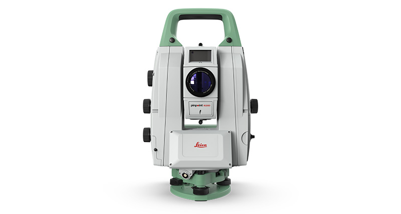
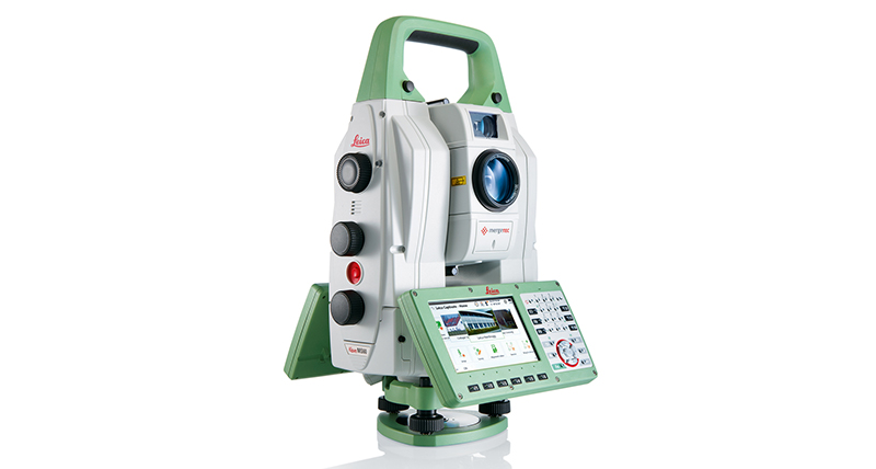
Leica Geosystems’ new monitoring solution comes with a strong promise: real-time information and reports you can always rely on, helping you make informed decisions in time and on time. Be it settling, flexing, shifting, sliding or any other change of state – you will have it under control 24 hours a day, seven days a week. The robust, precise and enduring TM60 comes with the world’s longest ATRplus range, half-second automatic aiming accuracy, advanced imaging and the longest continuous operation. Combined with the Leica GeoMoS monitoring solution, you will be able to react to complex demands of any project – be it continuous or periodic. The decision is easy: maximum safety, minimum risk, half-second at a time.
When to use the Leica Nova TM60:
- Permanent monitoring (24/7): remote operation, continuous monitoring, real-time measurement data, robust against various environmental conditions.
- Campaign monitoring (periodical): flexible instrument setup, automated measurements, Leica Captivate field software, dedicated monitoring app, connectivity to cloud services.
- Buildings and structures: monitoring of buildings, skyscrapers, industrial and sports facilities, offshore and underground structures.
- Transportation infrastructure: monitoring of tunnels, railway, bridges, roads & highways, airports, ports & canals.
- Environmental monitoring: monitoring of landslides, rock falls, subsidence.
- Energy infrastructure: monitoring of dams, oil & gas, nuclear facilities, pipelines power plants.
- Mining: monitoring of slope stability, high walls and quarries.
Leica Nova TM60 Monitoring Station
| ANGLE MEASUREMENT | ||
| Accuracy1 Hz and V | Absolute, continuous, quadruple | 0.5” (0.15 mgon) or 1” (0.3 mgon) |
| DISTANCE MEASUREMENT | ||
| Range2 | Prism (GPR1, GPH1P) 3 nNon-Prism / Any surface 4 | 0.9 m to 3,500 m 0.9 m to >1,000 m |
| Accuracy / Measurement time | Single (prism) 2,5 nSingle (any surface) 2,4,5,6 | 0.6 mm + 1 ppm / typ. 2.4 s 2 mm + 2 ppm / typ. 2 s 9 |
| Laser dot size | At 50 m | 8 mm x 20 mm |
| Measurement technology | System analyser | Coaxial, visible red laser |
| IMAGING7 | ||
| Overview and telescope camera | Sensor nField of view (overview / telescope) nFrame rate | 5 megapixel CMOS sensor 19.4° / 1.5° Up to 20 frames per second |
| MOTORISATION | ||
| Direct drives based on Piezo technology | Rotation speed / Time to change face | Maximum 200 gon (180°) per s / typically 2.9 s |
| AUTOMATIC AIMING – LONG RANGE ATRplus | ||
| Target aiming range 2 | nCircular prism (GPR1, GPH1P) n360° prism (GRZ4, GRZ122) | n3,000 m n1,500 m |
| Accuracy 1,2 / Measurement time | ATRplus angle accuracy Hz, V | 0.5” (0.15 mgon) or 1” (0.3 mgon) / typically 3-4 s |
| GENERAL | ||
| Operating System / Field Software | Windows EC7 / Leica Captivate with apps | |
| Processor | TI OMAP4430 1GHz Dual-core ARM® Cortex™- A9 MPCore™ | |
| Autofocus8 telescope | Magnification / Focus Range | 30 x / 1.7m to infinity |
| Display and keyboard | 5‘‘ (inch), WVGA, colour, touch, Face 1 standard,Face 2 optional | 37 keys, illumination |
| Operation | 3x endless drives, 1x Servofocus drive, 2x Autofocus keys 8, user-definable SmartKey | |
| Power management | Exchangeable Lithium-Ion battery with internal charging capability | Operating Time up to 9 h |
| Data storage | nInternal memory nMemory card | 2 GB SD card 1 GB or 8 GB |
| Interfaces | RS232, USB, Bluetooth®, WLAN | |
| Weight | Total station including battery | 7.2 kg |
| Environmental specifications | Working temperature range nDust & Water (IEC 60529) / Blowing rain nHumidity | –20°C to +50°C IP65 / MIL-STD-810G, Method 506.5-I 95%, non-condensing |
1 Standard deviation ISO 17123-3
2 Overcast, no haze, visibility about 40 km, no heat shimmer
3 0.9 m to 2,000 m for 360° prisms (GRZ4, GRZ122)
4 Object in shade, sky overcast, Kodak Gray Card (90% reflective)
5 Standard deviation ISO 17123-4
6 Distance > 500 m: Accuracy 4 mm + 2 ppm, Measurement Time typ. 6 s
7 Available on TM60 I models
8 Autofocus for TM60 I models, Servofocus only for TM60 models
9 Up to 50 m, max. measurement time 15 s for full range
Comments0